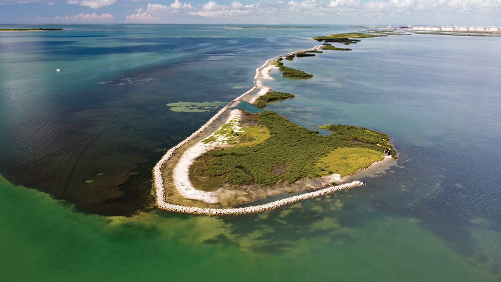
Protecting and Enhancing Estuary Habitats in the Redfish Bay State Scientific Area by Restoration of Dagger Island

Redfish Bay contains the northernmost extensive stands of seagrass on the Texas coast and is unique in that it is one of three bays that contain all five species of native seagrass in Texas. In 2000, the Texas Parks and Wildlife Department (TPWD) created the Redfish Bay State Scientific Area (RBSSA) for the purpose of protecting and studying the native seagrasses. The area contains approximately 50 square miles (32,000 acres) of prime fisheries habitat, including 14,000 acres of submerged seagrass beds dominated by turtle grass (Thalassia testudinum) and shoal grass (Halodule wrightii). In addition to seagrasses, the RBSSA contains other fragile biological communities including oyster reefs, tidal flats, mangroves and estuarine marshes that serve as valuable feeding and nursery habitat for commercial and recreational fishery and avian species. These habitats are critical for the health of the entire bay ecosystem and for sustaining a matrix of vertebrate and invertebrate species, many of which are of economical and recreational importance.
The value of these shallow water resources to recreational fisheries in Redfish Bay is evidenced by recent angler survey data collected from 2013 to 2017. Southern Redfish Bay represents only about 7% of the areal extent of the Corpus Christi Bay Ecosystem, yet survey data indicate that this small area accounted for 18% of the angling trips taken by boat and 21% of the angler hours throughout the Corpus Christi Bay Ecosystem. These survey data also indicate that southern Redfish Bay accounted for 37% of spotted seatrout, 31% of red drum, 23% of southern flounder, and 12% of black drum landed throughout the Corpus Christi Bay Ecosystem.
Dagger Island is in Redfish Bay due east of the Ingleside peninsula and immediately north of the Corpus Christi Ship Channel (CCSC) in Nueces County, TX and acts as a natural protective barrier for estuarine habitats in RBSSA. Since 1956, the southern section of Dagger Island has lost over 89 acres and the northernmost section of Dagger Island has lost over 35 acres of land due to erosion from both natural and human causes. The natural causes of shoreline erosion include the predominant southeast winds, storm events and decades of sea level rise accompanied by subsidence. Direct human impacts contributing to the erosion include high energy ship wakes caused by vessels traveling down the CCSC and extensive dredging from past oil and gas explorations. Future dredging projects and the widening and deepening of the CCSC to allow larger vessels to transit to existing and proposed docking basins will only exacerbate the problem. Because of the ecological and economical importance of this area, TPWD was concerned that if Dagger Island erosion continues, it could have harmful impacts on the aquatic resources within and surrounding the RBSSA. To address these concerns, TPWD initiated discussions of options to protect Dagger Island and the surrounding Redfish Bay ecosystem.
The natural resource objectives of this project were to protect and conserve approximately 5,200 acres of diverse estuarine habitats within the RBSSA, eliminate shoreline erosion of the island, create oyster, invertebrate and fisheries habitat, develop a natural living shoreline and restore approximately 25 acres of land lost to historical island erosion.
A preliminary evaluation was conducted to identify feasible alternatives for shoreline protection based on cost, environmental impact and location of the protection. The desktop analysis evaluated nine different shoreline protection methods based on 12 parameters and recommended three alternatives for further consideration: (1) quarry-stone revetment, (2) nearshore reef breakwater, and (3) offshore quarry-stone segmented breakwater.
Assessments for bathymetry, topography and geotechnical composition were performed to determine the best protection design, construction method and site placement for the shoreline stabilization project. Using the desktop analysis and site surveys, three priority areas were identified for potential shoreline protection based on shoreline erosion rates. After reviewing the recommendations for shoreline protection alternatives, a combination of nearshore and offshore breakwaters was selected. Nearshore breakwaters, located within 100 feet of the shoreline, provide protection by intercepting incoming waves and creating intertidal zones between the shore and breakwater structures. To further protect and enhance the shoreline, a living shoreline will be created through the planting of smooth cordgrass and saltmeadow cordgrass in the intertidal zone. Offshore breakwaters protect from incoming waves but provide additional protection from winds that blow across a long fetch. They are used in cases where nearshore breakwaters would impact natural resources, in this case, existing seagrass beds. In addition, twenty-five acres of the northern section of Dagger Island will be restored by constructing containment levees for the beneficial use of dredge material.
The shoreline protection and habitat restoration project were a collaborative effort between TPWD and Ducks Unlimited (DU), with funding provided primarily by TPWD using funding awards from National Fish and Wildlife Foundation (NFWF) – Gulf Environment Benefit Fund and Texas General Land Office. Additional project funding was secured from DU, Coastal Conservation Association – Texas/Building Conservation Trust and federal funds from a North American Wetlands Conservation Act grant. Part of the preliminary design funding was acquired through a grant from the Coastal Bend Bays and Estuaries Program.
The completed project includes 6,765 linear feet of nearshore breakwater along south Dagger Island and adjacent to the beneficial use site. A total of 6,185 linear feet of levees were constructed to restore 24.8 acres of eroded land by placement of approximately 260,000 cubic yards of dredge material. Dredge material donors are currently being sought to immediately fill the beneficial use site.
In addition to the original objectives, predicted project benefits include return of seagrass beds in bare areas behind the beneficial use site, restoration of healthy smooth cordgrass and saltmeadow cordgrass habitats, a new site for avian resting, roosting and nesting, and another venue for recreational fishing opportunities in Redfish Bay.
